Project
Community
News
My App
My maps
Maps of Osztopán
Advanced search
All
Private
Favorites
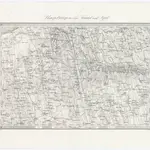
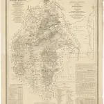
Umgebungen von Karád und Igal
1873|Militärgeographisches Institut
1:144 000
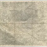
Eszeg
1873|Militärgeographisches Institut
1:300 000
[Fünf Kirchen
1873|Militärgeographisches Institut
1:300 000
V.3:11-15:XII: 2. Oesterreich. C. Ungarische erbstaaten, I. Koenigr: Ungarn, Gespanschaft 22-24
1828|Hermann, O.
1:200 000
Mappa geographica almae dioecesis Weszprimiensis per inclytos comitatus Weszprim, Simigh et Zala
1841|Vizer, Stephan
1:240 000
V.3:11-15:XII: 2. Oesterreich. C. Ungarische erbstaaten, I. Koenigr: Ungarn, Gespanschaft 14-15 & 20-21
1828|Hermann, O.
1:200 000
Croquis von Croatien und Slavonien
1860
1600
1650
1700
1750
1800
1850
1900
1950
2000
History
Old maps of Osztopán
Discover the past of Osztopán on historical maps
Old maps of Osztopán
Discover the past of Osztopán on historical maps
Explore Maps
Discover History
Parent places
Kaposvár District
Related places
© MapTiler
© OpenStreetMap
 1873|Militärgeographisches Institut1:144 000
 1873|Militärgeographisches Institut1:300 000
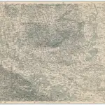 1873|Militärgeographisches Institut1:300 000
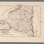 1828|Hermann, O.1:200 000
 1841|Vizer, Stephan1:240 000
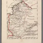 1828|Hermann, O.1:200 000
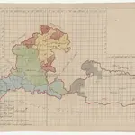 1860
1860