Project
Community
News
My App
My maps
Maps of Nemesmedves
Advanced search
All
Private
Favorites
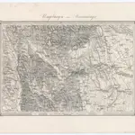
Umgebungen von Steinamanger
1873|Militärgeographisches Institut
1:144 000
Spezial Karte des Marburger Kreises im Herzogthum Steyermark
1841|Jos. Fr. Kaiser
1:220 000
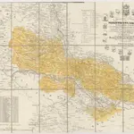
Comitat Eisenburg
1840
1:290 000
Special Karte des Marburger Kreises im Herzogthume Steyermark
1836|Jos. Fr. Kaiser
1:200 000
Neueste special Karte des Gratzer Kreises im Herzogthume Steyermark
1836|Jos. Fr. Kaiser
1:213 000
Spezial Karte des Marburger Kreises im Herzogthum Steyermark
1836|Jos. Fr. Kaiser
1:220 000
[Gratz
1873|Militärgeographisches Institut
1:300 000
1600
1650
1700
1750
1800
1850
1900
1950
2000
History
Old maps of Nemesmedves
Discover the past of Nemesmedves on historical maps
Old maps of Nemesmedves
Discover the past of Nemesmedves on historical maps
Explore Maps
Discover History
Parent places
Körmend District
Related places
© MapTiler
© OpenStreetMap
 1873|Militärgeographisches Institut1:144 000
 1841|Jos. Fr. Kaiser1:220 000
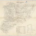 18401:290 000
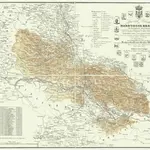 1836|Jos. Fr. Kaiser1:200 000
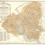 1836|Jos. Fr. Kaiser1:213 000
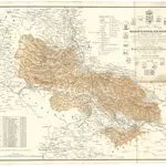 1836|Jos. Fr. Kaiser1:220 000
 1873|Militärgeographisches Institut1:300 000