Project
Community
News
My App
My maps
Maps of Holy Cross, Iowa
Advanced search
All
Private
Favorites
Map of Dubuque County and view of Lorimier House, Dubuque, Iowa.
1875|Andreas, A. T. (Alfred Theodore), 1839-1900
1:154 800
Iowa
1842|Breese, S.
1:900 000
Iowa.
1842
Sectional Map of the State of Iowa
1869|Chapman, Silas
1:650 000
Iowa.
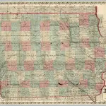
1874|Colton, G.W.
1:950 000
Iowa.
1869|Colton, G.W.
1:950 000
Wisconsin.
1842|Tanner, Henry S.
1:1 370 000
1600
1650
1700
1750
1800
1850
1900
1950
2000
History
Old maps of Holy Cross, Iowa
Discover the past of Holy Cross, Iowa on historical maps
Old maps of Holy Cross, Iowa
Discover the past of Holy Cross, Iowa on historical maps
Explore Maps
Discover History
Parent places
Dubuque County, Iowa
Related places
© MapTiler
© OpenStreetMap
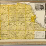 1875|Andreas, A. T. (Alfred Theodore), 1839-19001:154 800
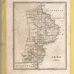 1842|Breese, S.1:900 000
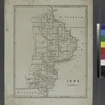 1842
1842
 1869|Chapman, Silas1:650 000
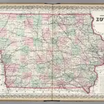 1874|Colton, G.W.1:950 000
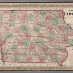 1869|Colton, G.W.1:950 000
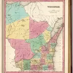 1842|Tanner, Henry S.1:1 370 000