Project
Community
News
My App
My maps
Maps of Białobrzegi-Kolonia
Advanced search
All
Private
Favorites
Lublin
1873|Militärgeographisches Institut
1:300 000
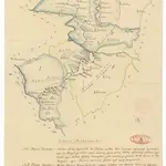
Obwod Białostocki
1820
[Polen]
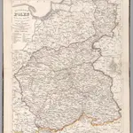
1870|S. Hirzel
1:800 000
V.3:11-15:XIV. Polen. Woiwodschaft: 2-5, und Rep: Krakau
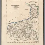
1829|Hermann, O.
1:430 000
V.3:11-15:XIV. Polen. Woiwodschaft: 1. Mosovien. 6. Podlachien. 7. Plock. 8. Augustow
1829|Hermann, O.
1:430 000
[Neuer Atlas der ganzen Erde nach den neuesten Bestimmungen ... : XXI.] Das Königreich Polen und der Freistaat Krakau
1831|Entworfen und gezeichnet von Dr. F.W. Streit
Konigreich Polen
1846|Stein, Christ. Gottfr. Dan.
1:260 000
1600
1650
1700
1750
1800
1850
1900
1950
2000
History
Old maps of Białobrzegi-Kolonia
Discover the past of Białobrzegi-Kolonia on historical maps
Old maps of Białobrzegi-Kolonia
Discover the past of Białobrzegi-Kolonia on historical maps
Explore Maps
Discover History
Parent places
Gmina Kock
Related places
© MapTiler
© OpenStreetMap
 1873|Militärgeographisches Institut1:300 000
 1820
1820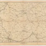 1870|S. Hirzel1:800 000
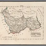 1829|Hermann, O.1:430 000
 1829|Hermann, O.1:430 000
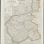 1831|Entworfen und gezeichnet von Dr. F.W. Streit
 1846|Stein, Christ. Gottfr. Dan.1:260 000